


| The World Factbook | ||
|
|
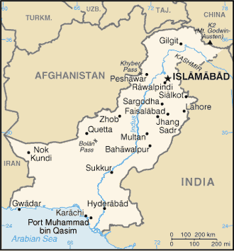
Pakistan |
|
|
| Introduction | Pakistan |
|
Background:
|
The separation in 1947 of British India into the Muslim state of Pakistan (with two sections West and East) and largely Hindu India was never satisfactorily resolved, and India and Pakistan have fought two wars - in 1947-48 and 1965 - over the disputed Kashmir territory. A third war between these countries in 1971 - in which India capitalized on Islamabad's marginalization of Bengalis in Pakistani politics - resulted in East Pakistan becoming the separate nation of Bangladesh. In response to Indian nuclear weapons testing, Pakistan conducted its own tests in 1998. The dispute over the state of Kashmir is ongoing, but recent discussions and confidence-building measures may be a start toward lessened tensions. |
| Geography | Pakistan |
|
Location:
|
Southern Asia, bordering the Arabian Sea, between India on the east and Iran and Afghanistan on the west and China in the north |
|
Geographic coordinates:
|
30 00 N, 70 00 E |
|
Map references:
|
Asia |
|
Area:
|
total: 803,940 sq km
land: 778,720 sq km water: 25,220 sq km |
|
Area - comparative:
|
slightly less than twice the size of California |
|
Land boundaries:
|
total: 6,774 km
border countries: Afghanistan 2,430 km, China 523 km, India 2,912 km, Iran 909 km |
|
Coastline:
|
1,046 km |
|
Maritime claims:
|
territorial sea: 12 nm
continental shelf: 200 nm or to the edge of the continental margin contiguous zone: 24 nm exclusive economic zone: 200 nm |
|
Climate:
|
mostly hot, dry desert; temperate in northwest; arctic in north |
|
Terrain:
|
flat Indus plain in east; mountains in north and northwest; Balochistan plateau in west |
|
Elevation extremes:
|
lowest point: Indian Ocean 0 m
highest point: K2 (Mt. Godwin-Austen) 8,611 m |
|
Natural resources:
|
land, extensive natural gas reserves, limited petroleum, poor quality coal, iron ore, copper, salt, limestone |
|
Land use:
|
arable land: 27.87%
permanent crops: 0.87% other: 71.26% (2001) |
|
Irrigated land:
|
180,000 sq km (1998 est.) |
|
Natural hazards:
|
frequent earthquakes, occasionally severe especially in north and west; flooding along the Indus after heavy rains (July and August) |
|
Environment - current issues:
|
water pollution from raw sewage, industrial wastes, and agricultural runoff; limited natural fresh water resources; a majority of the population does not have access to potable water; deforestation; soil erosion; desertification |
|
Environment - international agreements:
|
party to: Biodiversity, Climate Change, Desertification, Endangered Species, Environmental Modification, Hazardous Wastes, Law of the Sea, Marine Dumping, Ozone Layer Protection, Ship Pollution, Wetlands
signed, but not ratified: Marine Life Conservation |
|
Geography - note:
|
controls Khyber Pass and Bolan Pass, traditional invasion routes between Central Asia and the Indian Subcontinent |
| People | Pakistan |
|
Population:
|
159,196,336 (July 2004 est.) |
|
Age structure:
|
0-14 years: 40.2% (male 32,919,441; female 31,058,929)
15-64 years: 55.8% (male 45,381,469; female 43,377,613) 65 years and over: 4.1% (male 3,123,594; female 3,335,290) (2004 est.) |
|
Median age:
|
total: 19.4 years
male: 19.2 years female: 19.5 years (2004 est.) |
|
Population growth rate:
|
1.98% (2004 est.) |
|
Birth rate:
|
31.22 births/1,000 population (2004 est.) |
|
Death rate:
|
8.67 deaths/1,000 population (2004 est.) |
|
Net migration rate:
|
-2.77 migrant(s)/1,000 population (2004 est.) |
|
Sex ratio:
|
at birth: 1.05 male(s)/female
under 15 years: 1.06 male(s)/female 15-64 years: 1.05 male(s)/female 65 years and over: 0.94 male(s)/female total population: 1.05 male(s)/female (2004 est.) |
|
Infant mortality rate:
|
total: 74.43 deaths/1,000 live births
female: 74 deaths/1,000 live births (2004 est.) male: 74.84 deaths/1,000 live births |
|
Life expectancy at birth:
|
total population: 62.61 years
male: 61.69 years female: 63.58 years (2004 est.) |
|
Total fertility rate:
|
4.29 children born/woman (2004 est.) |
|
HIV/AIDS - adult prevalence rate:
|
0.1% (2001 est.) |
|
HIV/AIDS - people living with HIV/AIDS:
|
78,000 (2001 est.) |
|
HIV/AIDS - deaths:
|
4,500 (2001 est.) |
|
Nationality:
|
noun: Pakistani(s)
adjective: Pakistani |
|
Ethnic groups:
|
Punjabi, Sindhi, Pashtun (Pathan), Baloch, Muhajir (immigrants from India at the time of partition and their descendants) |
|
Religions:
|
Muslim 97% (Sunni 77%, Shi'a 20%), Christian, Hindu, and other 3% |
|
Languages:
|
Punjabi 48%, Sindhi 12%, Siraiki (a Punjabi variant) 10%, Pashtu 8%, Urdu (official) 8%, Balochi 3%, Hindko 2%, Brahui 1%, English (official and lingua franca of Pakistani elite and most government ministries), Burushaski, and other 8% |
|
Literacy:
|
definition: age 15 and over can read and write
total population: 45.7% male: 59.8% female: 30.6% (2003 est.) |
| Government | Pakistan |
|
Country name:
|
conventional long form: Islamic Republic of Pakistan
conventional short form: Pakistan former: West Pakistan |
|
Government type:
|
federal republic |
|
Capital:
|
Islamabad |
|
Administrative divisions:
|
4 provinces, 1 territory*, and 1 capital territory**; Balochistan, Federally Administered Tribal Areas*, Islamabad Capital Territory**, North-West Frontier Province, Punjab, Sindh
note: the Pakistani-administered portion of the disputed Jammu and Kashmir region includes Azad Kashmir and the Northern Areas |
|
Independence:
|
14 August 1947 (from UK) |
|
National holiday:
|
Republic Day, 23 March (1956) |
|
Constitution:
|
10 April 1973, suspended 5 July 1977, restored with amendments 30 December 1985; suspended 15 October 1999, restored 31 December 2002 |
|
Legal system:
|
based on English common law with provisions to accommodate Pakistan's status as an Islamic state; accepts compulsory ICJ jurisdiction, with reservations |
|
Suffrage:
|
18 years of age; universal; joint electorates and reserved parliamentary seats for women and non-Muslims |
|
Executive branch:
|
note: following a military takeover on 12 October 1999, Chief of Army Staff and Chairman of the Joint Chiefs of Staff Committee, General Pervez MUSHARRAF, suspended Pakistan's constitution and assumed the additional title of Chief Executive; on 12 May 2000, Pakistan's Supreme Court unanimously validated the October 1999 coup and granted MUSHARRAF executive and legislative authority for three years from the coup date; on 20 June 2001, MUSHARRAF named himself as president and was sworn in, replacing Mohammad Rafiq TARAR; in a referendum held on 30 April 2002, MUSHARRAF's presidency was extended by five more years; on 1 January 2004, MUSHARRAF won a vote of confidence in the Senate, National Assembly, and four provincial assemblies
chief of state: President General Pervez MUSHARRAF (since 20 June 2001) head of government: Prime Minister Shaukat AZIZ (since 28 August 2004) cabinet: Cabinet appointed by the Prime Minister election results: AZIZ elected by the National Assembly on 27 August 2004 with 191 of the votes elections: the president is elected by Parliament for a five-year term; note - in a referendum held on 30 April 2002, MUSHARRAF's presidency was extended by five more years (next to be held NA 2007); the prime minister is selected by the National Assembly for a five-year term (next to be held NA 2007) |
|
Legislative branch:
|
bicameral Parliament or Majlis-e-Shoora consists of the Senate (100 seats - formerly 87; members indirectly elected by provincial assemblies to serve four-year terms; and the National Assembly (342 seats - formerly 217; 60 seats represent women; 10 seats represent minorities; members elected by popular vote to serve four-year terms)
election results: Senate results - percent of vote by party - NA; seats by party - PML/Q 40, PPPP 11, MMA 21, MQM/A 6, PML/N 4, NA 3, PML/F 1, PkMAP 2, ANP 2, PPP/S 2, JWP 1, BNP-Awami 1, BNP-Mengal 1, BNM/H 1, independents 4; National Assembly results - percent of votes by party - NA; seats by party - PML/Q 126, PPPP 81, MMA 63, PML/N 19, MQM/A 17, NA 16, PML/F 5, PML/J 3, PPP/S 2, BNP 1, JWP 1, PAT 1, PML/Z 1, PTI 1, MQM/H 1, PkMAP 1, independents 3 elections: Senate - last held 24 and 27 February 2003 (next to be held by February 2007); National Assembly - last held 10 October 2002 (next to be held by October 2006) |
|
Judicial branch:
|
Supreme Court (justices appointed by the president); Federal Islamic or Shari'a Court |
|
Political parties and leaders:
|
Awami National Party or ANP [Wali KHAN]; Balochistan National Movement/Hayee Group or BNM/H [Dr. Hayee BALUCH]; Baluch National Party-Mengal or BNP/M [Sardar Ataullah MENGAL]; Baluch National Party/Awami or BNP/Awami [Moheem Khan BALOCH]; Jamhoori Watan Party or JWP [Akbar Khan BUGTI]; Jamiat-al-Hadith or JAH [Sajid MIR]; Jamiat Ulema-i-Islam, Fazlur Rehman faction or JUI/F [Fazlur REHMAN]; Jamiat Ulema-i-Islam, Sami ul-HAQ faction or JUI/S [Sami ul-HAQ]; Jamiat-i-Islami or JI [Qazi Hussain AHMED]; Jamiat Ulema-i-Pakistan or JUP [Shah Faridul HAQ]]; Millat Party or MP [Farooq LEGHARI]; Muttahida Qaumi Movement, Altaf faction or MQM/A [Altaf HUSSAIN]; Muttahida Quami Movement, Haqiqi faction or MQM/H [Afaq AHMAD]; Muttahida Majlis-e-Amal Pakistan or MMA [Qazi Hussain AHMED]; National People's Party or NPP [Ghulam Mustapha JATOI]; Pakhtun Khwa Milli Awami Party or PkMAP [Mahmood Khan ACHAKZAI]; Pakhtun Quami Party or PQP [Mohammed Afzal KHAN]; Pakistan Awami Tehrik or PAT [Tahir ul QADRI]; Pakistan Democratic Party or PDP [Mehbooba Mufti SAYEED]; Pakistan Muslim League, Functional Group or PML/F [Pir PAGARO]; Pakistan Muslim League, Nawaz Sharif faction or PML/N [Nawaz SHARIF]; Pakistan Muslim League or PML [Chaudhry Shujaat HUSSAIN]; note - as of May 2004, the PML/Q changed its name to PML and absorbed the PML/J, PML/Z, and NA; Pakistan National Party or PNP [Hasil BIZENJO]; Pakistan People's Party or PPP [Aftab Ahmed Khan SHERPAO]; Pakistan People's Party Parliamentarians or PPPP [Benazir BHUTTO]; Pakistan Tehrik-e-Insaaf or PTI [Imran KHAN]; Tehrik-i-Islami [Allama Sajid NAQVI]
note: political alliances in Pakistan can shift frequently |
|
Political pressure groups and leaders:
|
military remains most important political force; ulema (clergy), landowners, industrialists, and small merchants also influential |
|
International organization participation:
|
ARF, AsDB, C (reinstated 2004), CP, ECO, FAO, G-24, G-77, IAEA, IBRD, ICAO, ICC, ICFTU, ICRM, IDA, IDB, IFAD, IFC, IFRCS, IHO, ILO, IMF, IMO, Interpol, IOC, IOM, ISO, ITU, MIGA, MINURSO, MONUC, NAM, OAS (observer), OIC, ONUB, OPCW, PCA, SAARC, SACEP, UN, UNAMSIL, UNCTAD, UNESCO, UNHCR, UNIDO, UNITAR, UNMIK, UNMIL, UNMISET, UNOCI, UNOMIG, UPU, WCL, WCO, WFTU, WHO, WIPO, WMO, WToO, WTO |
|
Diplomatic representation in the US:
|
chief of mission: Ambassador Jehangir KARAMAT
FAX: [1] (202) 686-1534 consulate(s) general: Chicago, Houston, Los Angeles, New York, and Boston (Honarary) telephone: [1] (202) 243-3277 chancery: 3517 International Court, Washington, DC 20008 |
|
Diplomatic representation from the US:
|
chief of mission: Ambassador Ryan CROCKER
embassy: Diplomatic Enclave, Ramna 5, Islamabad mailing address: P. O. Box 1048, Unit 62200, APO AE 09812-2200 telephone: [92] (51) 2080-0000 FAX: [92] (51) 2276427 consulate(s): Karachi, Lahore, Peshawar |
|
Flag description:
|
green with a vertical white band (symbolizing the role of religious minorities) on the hoist side; a large white crescent and star are centered in the green field; the crescent, star, and color green are traditional symbols of Islam |
| Economy | Pakistan |
|
Economy - overview:
|
Pakistan, an impoverished and underdeveloped country, has suffered from decades of internal political disputes, low levels of foreign investment, and a costly, ongoing confrontation with neighboring India. However, IMF-approved government policies, bolstered by generous foreign assistance and renewed access to global markets since late 2001, have generated solid macroeconomic recovery the last two years. The government has made substantial inroads in macroeconomic reform since 2000, although progress on more politically sensitive reforms has slowed. For example, in the third and final year of its $1.3 billion IMF Poverty Reduction and Growth Facility, Islamabad has continued to require waivers for energy sector reforms. While long-term prospects remain uncertain, given Pakistan's low level of development, medium-term prospects for job creation and poverty reduction are the best in nearly a decade. Islamabad has raised development spending from about 2% of GDP in the 1990s to 4% in 2003, a necessary step towards reversing the broad underdevelopment of its social sector. GDP growth is heavily dependent on rain-fed crops, and last year's end to a four-year drought should support moderate agricultural growth for the next few years. Foreign exchange reserves continued to reach new levels in 2003, supported by robust export growth and steady worker remittances. |
|
GDP:
|
purchasing power parity - $318 billion (2003 est.) |
|
GDP - real growth rate:
|
5.5% (2003 est.) |
|
GDP - per capita:
|
purchasing power parity - $2,100 (2003 est.) |
|
GDP - composition by sector:
|
agriculture: 23.3%
industry: 23.5% services: 53.2% (2003 est.) |
|
Investment (gross fixed):
|
12.9% of GDP (2003) |
|
Population below poverty line:
|
35% (2001 est.) |
|
Household income or consumption by percentage share:
|
lowest 10%: 4.1%
highest 10%: 27.6% (FY96/97) |
|
Distribution of family income - Gini index:
|
41 (FY98/99) |
|
Inflation rate (consumer prices):
|
2.9% (2003 est.) |
|
Labor force:
|
43.98 million
note: extensive export of labor, mostly to the Middle East, and use of child labor (2003) |
|
Labor force - by occupation:
|
agriculture 44%, industry 17%, services 39% (1999 est.) |
|
Unemployment rate:
|
7.7% plus substantial underemployment (2003 est.) |
|
Budget:
|
revenues: $12.08 billion
expenditures: $15.41 billion, including capital expenditures of NA (2003 est.) |
|
Public debt:
|
72.7% of GDP (2003) |
|
Agriculture - products:
|
cotton, wheat, rice, sugarcane, fruits, vegetables; milk, beef, mutton, eggs |
|
Industries:
|
textiles and apparel, food processing, pharmaceuticals, construction materials, paper products, fertilizer, shrimp |
|
Industrial production growth rate:
|
7.6% (2003 est.) |
|
Electricity - production:
|
66.96 billion kWh (2001) |
|
Electricity - consumption:
|
62.27 billion kWh (2001) |
|
Electricity - exports:
|
0 kWh (2001) |
|
Electricity - imports:
|
0 kWh (2001) |
|
Oil - production:
|
62,870 bbl/day (2001 est.) |
|
Oil - consumption:
|
365,000 bbl/day (2001 est.) |
|
Oil - exports:
|
NA (2001) |
|
Oil - imports:
|
NA (2001) |
|
Oil - proved reserves:
|
297.1 million bbl (1 January 2002) |
|
Natural gas - production:
|
23.4 billion cu m (2001 est.) |
|
Natural gas - consumption:
|
23.4 billion cu m (2001 est.) |
|
Natural gas - exports:
|
0 cu m NA (2001 est.) |
|
Natural gas - imports:
|
0 cu m (2001 est.) |
|
Natural gas - proved reserves:
|
695.6 billion cu m (1 January 2002) |
|
Current account balance:
|
$3.358 billion (2003) |
|
Exports:
|
$11.7 billion f.o.b. (2003 est.) |
|
Exports - commodities:
|
textiles (garments, bed linen, cotton cloth, and yarn), rice, leather goods, sports goods, chemicals, manufactures, carpets and rugs |
|
Exports - partners:
|
US 23.1%, UAE 9.4%, UK 7.1%, Germany 5.1%, Hong Kong 4.6% (2003) |
|
Imports:
|
$12.51 billion f.o.b. (2003 est.) |
|
Imports - commodities:
|
petroleum, petroleum products, machinery, plastics, transportation equipment, edible oils, paper and paperboard, iron and steel, tea |
|
Imports - partners:
|
UAE 11.2%, Saudi Arabia 10.9%, China 7.3%, Japan 6.6%, Kuwait 6.4%, US 6%, Malaysia 4.6%, Germany 4.4%, Singapore 4% (2003) |
|
Reserves of foreign exchange & gold:
|
$11.67 billion (2003) |
|
Debt - external:
|
$33.54 billion (2003 est.) |
|
Economic aid - recipient:
|
$2.4 billion (FY01/02) |
|
Currency:
|
Pakistani rupee (PKR) |
|
Currency code:
|
PKR |
|
Exchange rates:
|
Pakistani rupees per US dollar - 57.752 (2003), 59.7238 (2002), 61.9272 (2001), 53.6482 (2000), 49.1183 (1999) |
|
Fiscal year:
|
1 July - 30 June |
| Communications | Pakistan |
|
Telephones - main lines in use:
|
3,982,800 (2003) |
|
Telephones - mobile cellular:
|
2,624,800 (2003) |
|
Telephone system:
|
general assessment: the domestic system is mediocre, but improving; service is adequate for government and business use, in part because major businesses have established their own private systems; since 1988, the government has promoted investment in the national telecommunications system on a priority basis, significantly increasing network capacity; despite major improvements in trunk and urban systems, telecommunication services are still not readily available to the majority of the rural population
domestic: microwave radio relay, coaxial cable, fiber-optic cable, cellular, and satellite networks international: country code - 92; satellite earth stations - 3 Intelsat (1 Atlantic Ocean and 2 Indian Ocean); 3 operational international gateway exchanges (1 at Karachi and 2 at Islamabad); microwave radio relay to neighboring countries (1999) |
|
Radio broadcast stations:
|
AM 27, FM 1, shortwave 21 (1998) |
|
Radios:
|
13.5 million (1997) |
|
Television broadcast stations:
|
22 (plus seven low-power repeaters) (1997) |
|
Televisions:
|
3.1 million (1997) |
|
Internet country code:
|
.pk |
|
Internet hosts:
|
15,124 (2003) |
|
Internet Service Providers (ISPs):
|
30 (2000) |
|
Internet users:
|
1.5 million (2002) |
| Transportation | Pakistan |
|
Railways:
|
total: 8,163 km
broad gauge: 7,718 km 1.676-m gauge (293 km electrified) narrow gauge: 445 km 1.000-m gauge (2003) |
|
Highways:
|
total: 254,410 km
paved: 109,396 km (including 339 km of expressways) unpaved: 145,014 km (1999) |
|
Pipelines:
|
gas 9,945 km; oil 1,821 km (2004) |
|
Ports and harbors:
|
Karachi, Port Muhammad bin Qasim |
|
Merchant marine:
|
total: 17 ships (1,000 GRT or over) 329,486 GRT/512,506 DWT
by type: cargo 11, container 2, petroleum tanker 4 registered in other countries: 16 (2004 est.) |
|
Airports:
|
129 (2003 est.) |
|
Airports - with paved runways:
|
total: 92
over 3,047 m: 14 2,438 to 3,047 m: 22 914 to 1,523 m: 18 under 914 m: 6 (2004 est.) 1,524 to 2,437 m: 32 |
|
Airports - with unpaved runways:
|
total: 39
over 3,047 m: 1 1,524 to 2,437 m: 8 under 914 m: 21 (2004 est.) 914 to 1,523 m: 9 |
|
Heliports:
|
15 (2003 est.) |
| Military | Pakistan |
|
Military branches:
|
Army, Navy, Air Force |
|
Military manpower - military age and obligation:
|
16 years of age for voluntary military service; soldiers cannot be deployed for combat until age of 18 (2001) |
|
Military manpower - availability:
|
males age 15-49: 39,793,586 (2004 est.) |
|
Military manpower - fit for military service:
|
males age 15-49: 24,355,985 (2004 est.) |
|
Military manpower - reaching military age annually:
|
males: 1,891,101 (2004 est.) |
|
Military expenditures - dollar figure:
|
$2.7 billion (FY02/03) |
|
Military expenditures - percent of GDP:
|
3.9% (FY02/03) |
| Transnational Issues | Pakistan |
|
Disputes - international:
|
Kashmir remains the world's largest and most highly militarized territorial dispute with portions under the de facto administration of China (Aksai Chin), India (Jammu and Kashmir), and Pakistan (Azad Kashmir, and Northern Areas), but recent discussions and confidence-building measures among the parties are beginning to defuse tensions; India does not recognize Pakistan's ceding lands to China in 1965 boundary agreement; disputes with Pakistan over Indus River water sharing and the terminus of the Sir Creek Estuary at the mouth of the Rann of Kutch, which prevents maritime boundary delimitation; Pakistani maps continue to show Junagadh claim in India's Gujarat State; despite largely successful UN efforts at voluntary repatriation, 2-3 million Afghan refugees continue to reside in Pakistan, many at their own choosing; Pakistan has sent troops into remote tribal areas to control the border with Afghanistan to stem organized terrorist and other illegal cross-border activities; regular meetings with Afghan and coalition allies aim to resolve periodic claims of boundary encroachments |
|
Refugees and internally displaced persons:
|
refugees (country of origin): 1,064,230 (Afghanistan)
IDPs: undetermined (government strikes on Islamic militants in South Waziristan) (2004) |
|
Illicit drugs:
|
opium poppy in Federally Administered Tribal Areas, North-West Frontier Province, and Balochistan Province has rebounded since it was nearly eliminated in 2001; key transit point for Afghan drugs, including heroin, opium, morphine, and hashish, bound for Western markets, the Gulf States, and Africa; financial crimes related to drug trafficking, terrorism, corruption, and smuggling remain problems |
|
This page was last updated on 10 February, 2005 |